|
Jump to your event
Staging Area
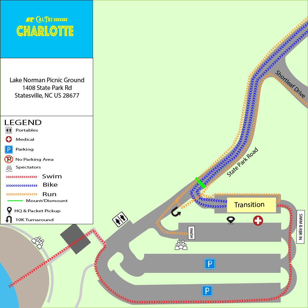
🔍 Click map to view full size in a new tab
Sprint Distance Events
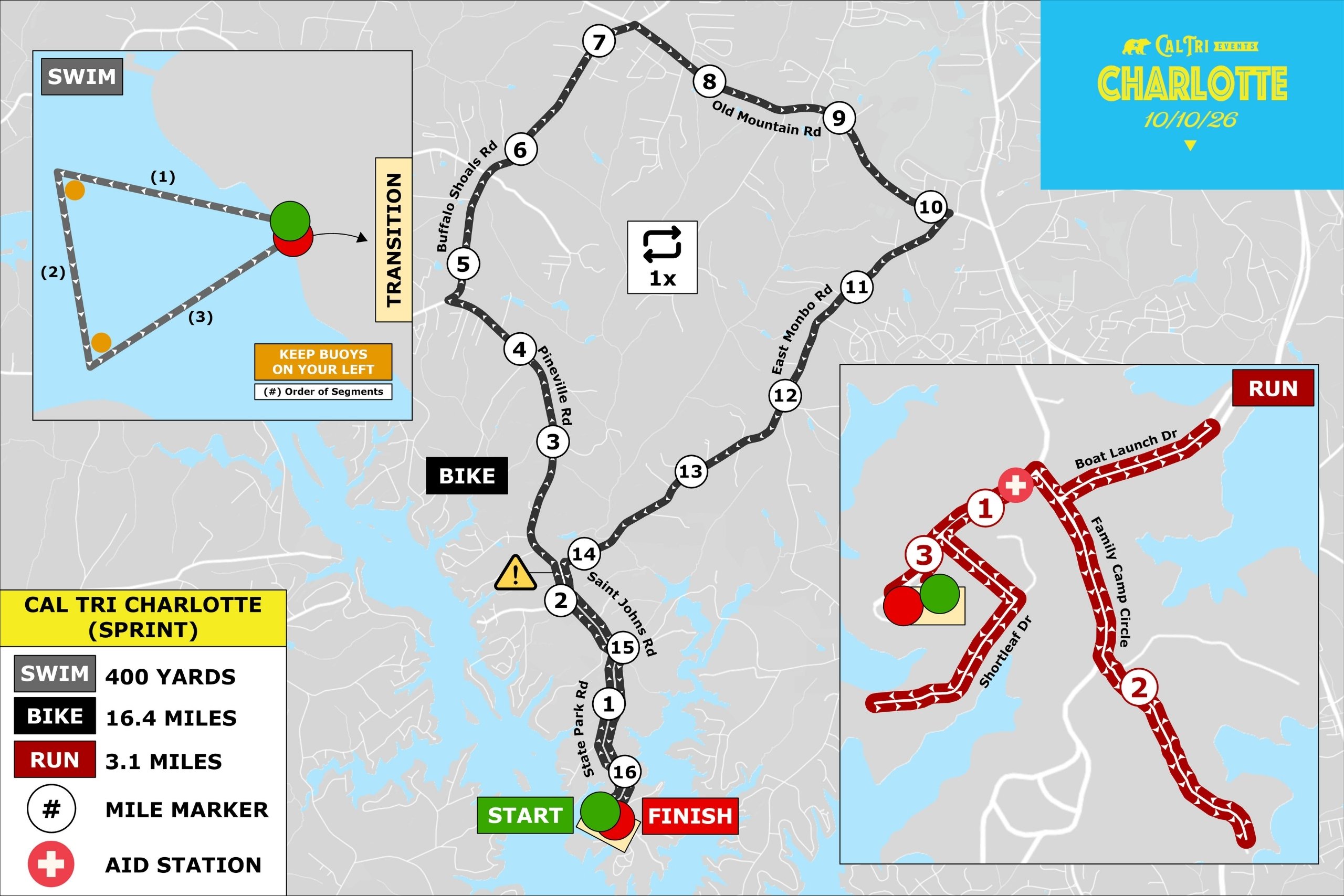
🏊🚴🏃 Sprint Triathlon
|
SWIM
400
yards
|
BIKE
16.4
miles
|
RUN
3.1
miles
|
📍 Start Location: Swim Beach
|
🔍 Click map to view full size in a new tab
🚴 Sprint Bike Cue Sheet
| 0.0 mi | Start on State Park Road |
| 1.4 mi | Turn left onto St Johns Rd |
| 2.0 mi | Turn right onto E Monbo Rd |
| 2.2 mi | Slight left onto Pineville Rd |
| 4.7 mi | Turn right onto Buffalo Shoals Rd |
| 7.3 mi | Turn right onto Old Mountain Rd |
| 10.1 mi | Turn right onto E Monbo Rd |
| 14.4 mi | Turn left onto St Johns Rd |
| 15.0 mi | Turn right on State Park Rd |
| 16.4 mi | Continue into Lake Norman Picnic Ground |
🏃 Sprint Run Cue Sheet
| 0.1 mi | Continue onto State Park Rd |
| 0.2 mi | Turn right onto Shortleaf Dr |
| 0.3 mi | Turn right to stay on Shortleaf Dr |
| 0.5 mi | Make a U Turn |
| 0.7 mi | Turn left to stay on Shortleaf Dr |
| 0.8 mi | Turn right onto State Park Rd |
| 1.0 mi | Turn right onto St Johns Rd |
| 1.2 mi | Slight right onto State Park Rd |
| 1.4 mi | Slight right onto Family Camp Cir |
| 1.5 mi | Turn left onto the access road |
| 1.5 mi | Turn left onto Family Camp Cir |
| 1.6 mi | Continue onto State Park Rd |
| 1.8 mi | Sharp right onto St Johns Rd |
| 2.1 mi | Make a U Turn |
| 2.8 mi | Turn left onto State Park Rd |
| 3.0 mi | Make a slight right to the finish line |
🏃🚴🏃 Sprint RunBikeRun
|
RUN 1
3.1
miles
|
BIKE
16.4
miles
|
RUN 2
3.1
miles
|
📍 Start Location: Finish Line Arch
📌 Reading this Map
The map below shows the full triathlon course for reference. As a RunBikeRun athlete, your race uses the black bike route and red run route only. Ignore the grey swim route.
|
🔍 Click map to view full size in a new tab
🚴 Sprint Bike Cue Sheet
| 0.0 mi | Start on State Park Road |
| 1.4 mi | Turn left onto St Johns Rd |
| 2.0 mi | Turn right onto E Monbo Rd |
| 2.2 mi | Slight left onto Pineville Rd |
| 4.7 mi | Turn right onto Buffalo Shoals Rd |
| 7.3 mi | Turn right onto Old Mountain Rd |
| 10.1 mi | Turn right onto E Monbo Rd |
| 14.4 mi | Turn left onto St Johns Rd |
| 15.0 mi | Turn right on State Park Rd |
| 16.4 mi | Continue into Lake Norman Picnic Ground |
🏃 Sprint Run Cue Sheet
| 0.1 mi | Continue onto State Park Rd |
| 0.2 mi | Turn right onto Shortleaf Dr |
| 0.3 mi | Turn right to stay on Shortleaf Dr |
| 0.5 mi | Make a U Turn |
| 0.7 mi | Turn left to stay on Shortleaf Dr |
| 0.8 mi | Turn right onto State Park Rd |
| 1.0 mi | Turn right onto St Johns Rd |
| 1.2 mi | Slight right onto State Park Rd |
| 1.4 mi | Slight right onto Family Camp Cir |
| 1.5 mi | Turn left onto the access road |
| 1.5 mi | Turn left onto Family Camp Cir |
| 1.6 mi | Continue onto State Park Rd |
| 1.8 mi | Sharp right onto St Johns Rd |
| 2.1 mi | Make a U Turn |
| 2.8 mi | Turn left onto State Park Rd |
| 3.0 mi | Make a slight right to the finish line |
🏊🚴 Sprint SwimBike
|
SWIM
400
yards
|
BIKE
16.4
miles
|
📍 Start Location: Swim Beach
📌 Reading this Map
The map below shows the full triathlon course for reference. As a SwimBike athlete, your race uses the grey swim route and black bike route only. Ignore the red run route.
|
🔍 Click map to view full size in a new tab
🚴 Sprint Bike Cue Sheet
| 0.0 mi | Start on State Park Road |
| 1.4 mi | Turn left onto St Johns Rd |
| 2.0 mi | Turn right onto E Monbo Rd |
| 2.2 mi | Slight left onto Pineville Rd |
| 4.7 mi | Turn right onto Buffalo Shoals Rd |
| 7.3 mi | Turn right onto Old Mountain Rd |
| 10.1 mi | Turn right onto E Monbo Rd |
| 14.4 mi | Turn left onto St Johns Rd |
| 15.0 mi | Turn right on State Park Rd |
| 16.4 mi | Continue into Lake Norman Picnic Ground |
🏊🏃 Sprint SwimRun
|
SWIM
400
yards
|
RUN
3.1
miles
|
📍 Start Location: Swim Beach
📌 Reading this Map
The map below shows the full triathlon course for reference. As a SwimRun athlete, your race uses the grey swim route and red run route only. Ignore the black bike route entirely. After your swim you go directly into the run, with no bike leg.
|
🔍 Click map to view full size in a new tab
Course Files on Ride with GPS
🏊 Swim Course🏃 Run Course
🏃 Sprint Run Cue Sheet
| 0.1 mi | Continue onto State Park Rd |
| 0.2 mi | Turn right onto Shortleaf Dr |
| 0.3 mi | Turn right to stay on Shortleaf Dr |
| 0.5 mi | Make a U Turn |
| 0.7 mi | Turn left to stay on Shortleaf Dr |
| 0.8 mi | Turn right onto State Park Rd |
| 1.0 mi | Turn right onto St Johns Rd |
| 1.2 mi | Slight right onto State Park Rd |
| 1.4 mi | Slight right onto Family Camp Cir |
| 1.5 mi | Turn left onto the access road |
| 1.5 mi | Turn left onto Family Camp Cir |
| 1.6 mi | Continue onto State Park Rd |
| 1.8 mi | Sharp right onto St Johns Rd |
| 2.1 mi | Make a U Turn |
| 2.8 mi | Turn left onto State Park Rd |
| 3.0 mi | Make a slight right to the finish line |
🏊 Sprint Swim
|
SWIM
400
yards
|
📍 Start Location: Swim Beach
📌 Reading this Map
The map below shows the full triathlon course for reference. As a 400 Yard Swim athlete, you complete the grey swim route only. Ignore the bike and run portions of the map entirely.
🔍 Click map to view full size in a new tab
Course Files on Ride with GPS
🏊 Swim Course🏃 5K Run
|
RUN
3.1
miles
|
📍 Start Location: Finish Line Arch
📌 Reading this Map
The map below shows the full triathlon course for reference. As a 5K Run athlete, you follow the red run route only. Ignore the swim and bike portions of the map entirely.
🔍 Click map to view full size in a new tab
Course Files on Ride with GPS
🏃 Run Course
🏃 Sprint Run Cue Sheet
| 0.1 mi | Continue onto State Park Rd |
| 0.2 mi | Turn right onto Shortleaf Dr |
| 0.3 mi | Turn right to stay on Shortleaf Dr |
| 0.5 mi | Make a U Turn |
| 0.7 mi | Turn left to stay on Shortleaf Dr |
| 0.8 mi | Turn right onto State Park Rd |
| 1.0 mi | Turn right onto St Johns Rd |
| 1.2 mi | Slight right onto State Park Rd |
| 1.4 mi | Slight right onto Family Camp Cir |
| 1.5 mi | Turn left onto the access road |
| 1.5 mi | Turn left onto Family Camp Cir |
| 1.6 mi | Continue onto State Park Rd |
| 1.8 mi | Sharp right onto St Johns Rd |
| 2.1 mi | Make a U Turn |
| 2.8 mi | Turn left onto State Park Rd |
| 3.0 mi | Make a slight right to the finish line |
Olympic Distance Events
🏊🚴🏃 Olympic Triathlon
|
SWIM
1,640
yards
|
BIKE
28.4
miles
|
RUN
6.1
miles
|
📍 Start Location: Swim Beach
|
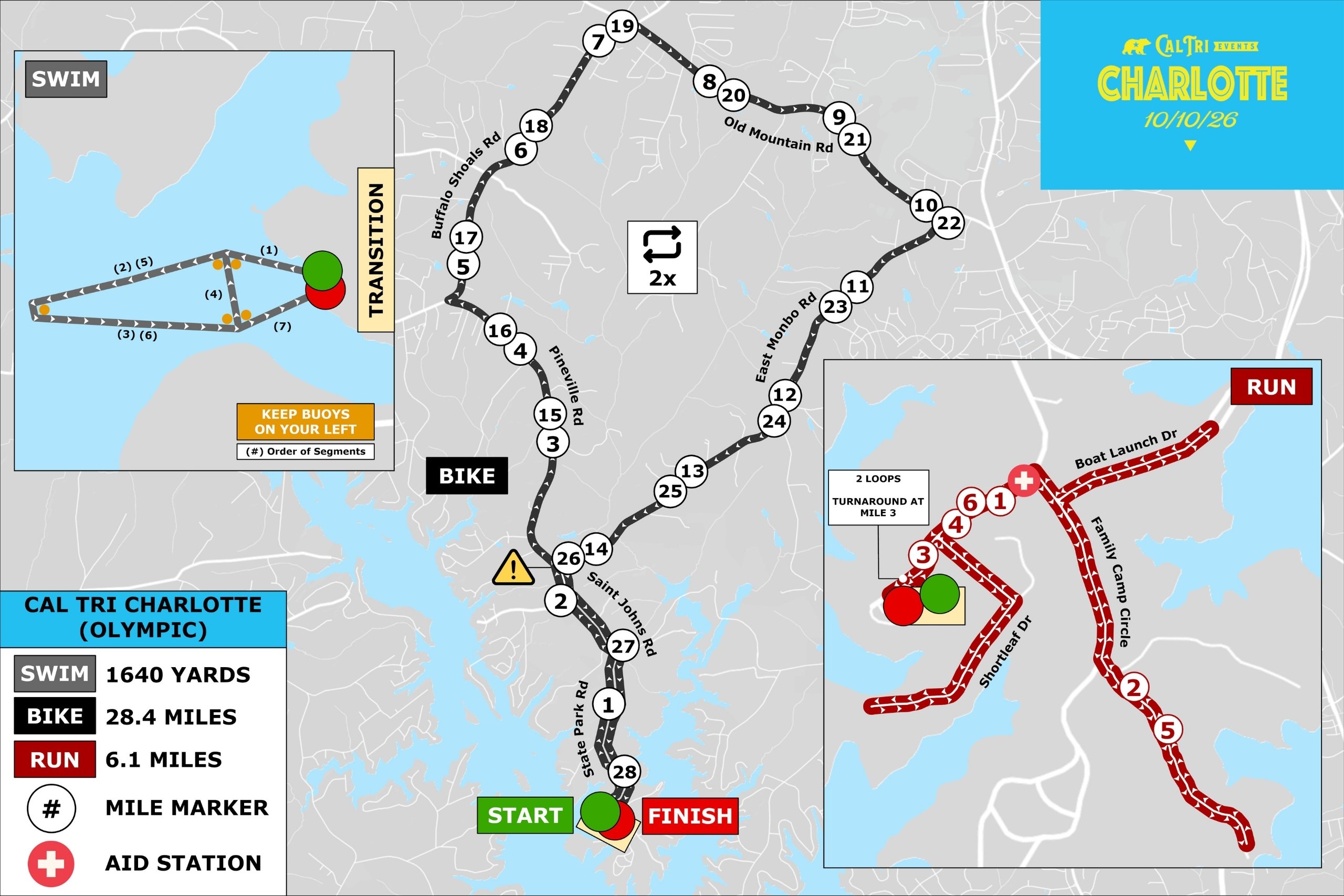
🔍 Click map to view full size in a new tab
🚴 Olympic Bike Cue Sheet
| 0.0 mi | Start on State Park Road |
| 1.4 mi | Turn left onto St Johns Rd |
| 2.0 mi | Turn right onto E Monbo Rd |
| 2.2 mi | Slight left onto Pineville Rd |
| 4.7 mi | Turn right onto Buffalo Shoals Rd |
| 7.3 mi | Turn right onto Old Mountain Rd |
| 10.1 mi | Turn right onto E Monbo Rd |
| 14.2 mi | Turn right onto Pineville Rd |
| 16.7 mi | Turn right onto Buffalo Shoals Rd |
| 19.3 mi | Turn right onto Old Mountain Rd |
| 22.1 mi | Turn right onto E Monbo Rd |
| 26.4 mi | Turn left onto St Johns Rd |
| 28.4 mi | Continue into Lake Norman Picnic Ground |
🏃 Olympic Run Cue Sheet
| 0.1 mi | Start on State Park Rd |
| 0.2 mi | Turn right onto Shortleaf Drive |
| 0.3 mi | Turn right to stay on Shortleaf Dr |
| 0.5 mi | Make a U Turn |
| 0.7 mi | Turn left to stay on Shortleaf Dr |
| 0.9 mi | Turn right onto State Park Rd |
| 1.0 mi | Turn right onto St Johns Rd |
| 1.3 mi | Slight right to stay on St. Johns Road |
| 1.4 mi | Slight right onto Family Camp Cir |
| 1.6 mi | Slight left to stay on Family Camp Cir |
| 1.9 mi | Continue onto State Park Rd |
| 2.0 mi | Sharp right onto St Johns Rd |
| 2.7 mi | Take a slight right to stay on State Park Rd |
| 3.0 mi | Turn left onto State Park Rd |
| 3.1 mi | Turn left onto Shortleaf Dr |
| 3.3 mi | Turn right to stay on Shortleaf Dr |
| 3.4 mi | Make a U Turn |
| 3.6 mi | Turn left to stay on Shortleaf Dr |
| 3.8 mi | Turn right onto State Park Rd |
| 3.9 mi | Turn right onto St Johns Rd |
| 4.2 mi | Slight right onto State Park Rd |
| 4.4 mi | Slight right onto Family Camp Cir |
| 4.5 mi | Slight left to stay on Family Camp Cir |
| 4.8 mi | Continue onto State Park Rd |
| 4.9 mi | Sharp right onto St Johns Rd |
| 5.2 mi | Make a U Turn |
| 5.9 mi | Turn left onto State Park Rd |
| 6.1 mi | Make a slight right to the finish line |
🏃🚴🏃 Olympic RunBikeRun
|
RUN 1
3.1
miles
|
BIKE
28.4
miles
|
RUN 2
6.1
miles
|
📍 Start Location: Finish Line Arch
📌 Reading this Map
The map below shows the full Olympic triathlon course for reference. As an Olympic RunBikeRun athlete, your race uses the black bike route and red run route only. Ignore the grey swim route.
Run #1 is one loop of the run course before heading to the bike.
Run #1 is one loop of the run course before heading to the bike.
|
🔍 Click map to view full size in a new tab
🚴 Olympic Bike Cue Sheet
| 0.0 mi | Start on State Park Road |
| 1.4 mi | Turn left onto St Johns Rd |
| 2.0 mi | Turn right onto E Monbo Rd |
| 2.2 mi | Slight left onto Pineville Rd |
| 4.7 mi | Turn right onto Buffalo Shoals Rd |
| 7.3 mi | Turn right onto Old Mountain Rd |
| 10.1 mi | Turn right onto E Monbo Rd |
| 14.2 mi | Turn right onto Pineville Rd |
| 16.7 mi | Turn right onto Buffalo Shoals Rd |
| 19.3 mi | Turn right onto Old Mountain Rd |
| 22.1 mi | Turn right onto E Monbo Rd |
| 26.4 mi | Turn left onto St Johns Rd |
| 28.4 mi | Continue into Lake Norman Picnic Ground |
🏃 Olympic Run Cue Sheet
| 0.1 mi | Start on State Park Rd |
| 0.2 mi | Turn right onto Shortleaf Drive |
| 0.3 mi | Turn right to stay on Shortleaf Dr |
| 0.5 mi | Make a U Turn |
| 0.7 mi | Turn left to stay on Shortleaf Dr |
| 0.9 mi | Turn right onto State Park Rd |
| 1.0 mi | Turn right onto St Johns Rd |
| 1.3 mi | Slight right to stay on St. Johns Road |
| 1.4 mi | Slight right onto Family Camp Cir |
| 1.6 mi | Slight left to stay on Family Camp Cir |
| 1.9 mi | Continue onto State Park Rd |
| 2.0 mi | Sharp right onto St Johns Rd |
| 2.7 mi | Take a slight right to stay on State Park Rd |
| 3.0 mi | Turn left onto State Park Rd |
| 3.1 mi | Turn left onto Shortleaf Dr |
| 3.3 mi | Turn right to stay on Shortleaf Dr |
| 3.4 mi | Make a U Turn |
| 3.6 mi | Turn left to stay on Shortleaf Dr |
| 3.8 mi | Turn right onto State Park Rd |
| 3.9 mi | Turn right onto St Johns Rd |
| 4.2 mi | Slight right onto State Park Rd |
| 4.4 mi | Slight right onto Family Camp Cir |
| 4.5 mi | Slight left to stay on Family Camp Cir |
| 4.8 mi | Continue onto State Park Rd |
| 4.9 mi | Sharp right onto St Johns Rd |
| 5.2 mi | Make a U Turn |
| 5.9 mi | Turn left onto State Park Rd |
| 6.1 mi | Make a slight right to the finish line |
🏊🚴 Olympic SwimBike
|
SWIM
1,640
yards
|
BIKE
28.4
miles
|
📍 Start Location: Swim Beach
📌 Reading this Map
The map below shows the full Olympic triathlon course for reference. As an Olympic SwimBike athlete, your race uses the grey swim route and black bike route only. Ignore the red run route.
|
🔍 Click map to view full size in a new tab
🚴 Olympic Bike Cue Sheet
| 0.0 mi | Start on State Park Road |
| 1.4 mi | Turn left onto St Johns Rd |
| 2.0 mi | Turn right onto E Monbo Rd |
| 2.2 mi | Slight left onto Pineville Rd |
| 4.7 mi | Turn right onto Buffalo Shoals Rd |
| 7.3 mi | Turn right onto Old Mountain Rd |
| 10.1 mi | Turn right onto E Monbo Rd |
| 14.2 mi | Turn right onto Pineville Rd |
| 16.7 mi | Turn right onto Buffalo Shoals Rd |
| 19.3 mi | Turn right onto Old Mountain Rd |
| 22.1 mi | Turn right onto E Monbo Rd |
| 26.4 mi | Turn left onto St Johns Rd |
| 28.4 mi | Continue into Lake Norman Picnic Ground |
🏊🏃 Olympic SwimRun
|
SWIM
1,640
yards
|
RUN
6.1
miles
|
📍 Start Location: Swim Beach
📌 Reading this Map
The map below shows the full Olympic triathlon course for reference. As an Olympic SwimRun athlete, your race uses the grey swim route and red run route only. Ignore the black bike route entirely. After your swim you go directly into the run, with no bike leg.
|
🔍 Click map to view full size in a new tab
Course Files on Ride with GPS
🏊 Swim Course🏃 Run Course
🏃 Olympic Run Cue Sheet
| 0.1 mi | Start on State Park Rd |
| 0.2 mi | Turn right onto Shortleaf Drive |
| 0.3 mi | Turn right to stay on Shortleaf Dr |
| 0.5 mi | Make a U Turn |
| 0.7 mi | Turn left to stay on Shortleaf Dr |
| 0.9 mi | Turn right onto State Park Rd |
| 1.0 mi | Turn right onto St Johns Rd |
| 1.3 mi | Slight right to stay on St. Johns Road |
| 1.4 mi | Slight right onto Family Camp Cir |
| 1.6 mi | Slight left to stay on Family Camp Cir |
| 1.9 mi | Continue onto State Park Rd |
| 2.0 mi | Sharp right onto St Johns Rd |
| 2.7 mi | Take a slight right to stay on State Park Rd |
| 3.0 mi | Turn left onto State Park Rd |
| 3.1 mi | Turn left onto Shortleaf Dr |
| 3.3 mi | Turn right to stay on Shortleaf Dr |
| 3.4 mi | Make a U Turn |
| 3.6 mi | Turn left to stay on Shortleaf Dr |
| 3.8 mi | Turn right onto State Park Rd |
| 3.9 mi | Turn right onto St Johns Rd |
| 4.2 mi | Slight right onto State Park Rd |
| 4.4 mi | Slight right onto Family Camp Cir |
| 4.5 mi | Slight left to stay on Family Camp Cir |
| 4.8 mi | Continue onto State Park Rd |
| 4.9 mi | Sharp right onto St Johns Rd |
| 5.2 mi | Make a U Turn |
| 5.9 mi | Turn left onto State Park Rd |
| 6.1 mi | Make a slight right to the finish line |
🏊 Olympic Swim
|
SWIM
1,640
yards
|
📍 Start Location: Swim Beach
📌 Reading this Map
The map below shows the full Olympic triathlon course for reference. As an Olympic swim athlete, you complete the grey swim route only. Ignore the bike and run portions of the map entirely.
🔍 Click map to view full size in a new tab
Course Files on Ride with GPS
🏊 Swim Course🏃 10K Run
|
RUN
6
miles
|
📍 Start Location: Finish Line Arch
📌 Reading this Map
The map below shows the full Olympic triathlon course for reference. As a 10K Run athlete, you follow the red run route only. Ignore the swim and bike portions of the map entirely.
🔍 Click map to view full size in a new tab
Course Files on Ride with GPS
🏃 Run Course
🏃 Olympic Run Cue Sheet
| 0.1 mi | Start on State Park Rd |
| 0.2 mi | Turn right onto Shortleaf Drive |
| 0.3 mi | Turn right to stay on Shortleaf Dr |
| 0.5 mi | Make a U Turn |
| 0.7 mi | Turn left to stay on Shortleaf Dr |
| 0.9 mi | Turn right onto State Park Rd |
| 1.0 mi | Turn right onto St Johns Rd |
| 1.3 mi | Slight right to stay on St. Johns Road |
| 1.4 mi | Slight right onto Family Camp Cir |
| 1.6 mi | Slight left to stay on Family Camp Cir |
| 1.9 mi | Continue onto State Park Rd |
| 2.0 mi | Sharp right onto St Johns Rd |
| 2.7 mi | Take a slight right to stay on State Park Rd |
| 3.0 mi | Turn left onto State Park Rd |
| 3.1 mi | Turn left onto Shortleaf Dr |
| 3.3 mi | Turn right to stay on Shortleaf Dr |
| 3.4 mi | Make a U Turn |
| 3.6 mi | Turn left to stay on Shortleaf Dr |
| 3.8 mi | Turn right onto State Park Rd |
| 3.9 mi | Turn right onto St Johns Rd |
| 4.2 mi | Slight right onto State Park Rd |
| 4.4 mi | Slight right onto Family Camp Cir |
| 4.5 mi | Slight left to stay on Family Camp Cir |
| 4.8 mi | Continue onto State Park Rd |
| 4.9 mi | Sharp right onto St Johns Rd |
| 5.2 mi | Make a U Turn |
| 5.9 mi | Turn left onto State Park Rd |
| 6.1 mi | Make a slight right to the finish line |